The Forest
Roads Loop
The Heart Of The Forest Service Roads System
What It Is - On maps this area shows as the
Sylamore Experimental Forest. In the past this is where foresters conducted research on
tree growth. Seed orchards for certain tree species grew here as well. Today this is part
of the Sylamore Walk-In Turkey Hunting Area. You can see the abandoned buildings that once
served as the research station about 1.6 miles down 1113 from the intersection of 1102 and
1113.
How To Use It - By using the Loop as a giant
two-way roundabout you can connect to any of the interior back country roads at are not
dead ends. If you drive all the way around the Forest Loop the total distance is about
11.9 miles.
As A Recreation Area - This Loop is
more than just a roundabout. It gives access to many old dead end logging roads for
hunting, hiking, mountain biking, walking, and otherwise enjoying Nature. For details see Sylamore Walk-In Turkey
Hunting Area
Road 1101 connects the Culp Loop Tour
with the Forest Roads Loop.
Interactive Map
Click Green Point Numbers for Point Details & Directions
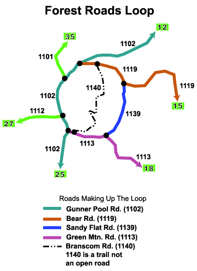
The Roads Making Up The Forest Loop -
Starting from 7 o'clock and going clockwise from where 1102 meets 1113, it is eight-tenths
of a mile to the intersection with 1112. From there it's another 1.4 miles to the
intersection with 1101, and from there it is another mile to the intersection with 1119.
From 1119 it's 2 miles to 1140 (horse trails), and it's 3 miles to 1139. From 1139 it's
about another 3 miles to the intersection with 1113, and from there it's about 2 miles
back to the point of beginning at the intersection of 1102 and 1113. Total distance is
right at 12 miles around the ring.
The road you will likely use the most on the Forest Roads
Loop is Gunner Pool Road, aka FSR-1102. This is the west side of the loop and it connects
to four other roads. It runs from Point 11 to Point 25 on the 2Cooleys map, and is a
little over 11 miles long from end to end.
Roads Connecting To The Loop - 1101 is aka
CR-74. 1102 is also Gunner Pool Road. 1112 is also Tie Ridge Road. 1113 is also Green
Road, or Green Mountain Road. 1119 is also Bear Road. 1139 is also Sandy Flat Road.
1140 is also Branscum Road. 1140 is not open to vehicle traffic and is part of both Horse
Trail A and Horse Trail B.
Roads From The Forest Loop Going Out:
1102 on the south end goes to Gunner Pool Recreation Area, then to Point 25 at Hwy
14.
1102 on the north end exits onto Hwy 5 at Point 12
1112 goes to the Horse Trail trailhead, and then on to Barkshed Recreation Area
1113 goes to three Syllamo Mountain Bike Trail trailheads and exits at Point 18
1119 goes to Hwy 5 at Point 15
1101 is the connecting road between the Forest Loop and the Culp Loop Tour
1140 only crosses the Forest Loop and is mostly used as a horse trail
1139 is the east side of the Forest Loop and goes nowhere else
From Hwy 5 at Point 11 to City Rock Bluff -
2.4 miles
From City Rock Bluff to intersection of Baxter CR 73 and CR 74 - 5 miles
From intersection of CR 73 and CR 74 to Point 36 - 6.8 miles
Total distance from Point 11 to Point 36 down Culp Road - 14.2 miles
Drive time without stops - 1 hour
Roads to Forest Roads Loop
From 2Cooleys Map Points |
Miles To Forest Loop |
| Point 12, 1102 (Gunner
Pool Road from north end ) |
3.2 |
| Point 15, 1119 (Bear
Road) |
3.6 |
| Point 18, 1113 (Green
Mtn. Road) |
7.1 |
| Point 25, 1102 (Gunner
Pool Road from south end) |
5.8 |
| Point 26, 1115
(Cartwright Road, turns into 1112) |
6.6 |
| Point 27, 1112 (Tie
Ridge Road) |
8.1 |
| Point 35, 1101
(McCowan Road) |
12.5 |
| Point 36, 1105 (Culp
Road) |
16.7 |
| 2 Example Runs Using
The Forest Loop To Connect two roads. |
|
| 1102 (Gunner Pool
Road) Point 12 to Point 25 |
12.1 |
| Point 35 to Point 18 |
23.6 |
FSR-1112
- If you follow 1112 from 1102 you'll come to Barkshed Recreation Area at 3.2 miles, and
if you keep going on 1112 you'll come out on Hwy 14 at Point 27. If you want to stop at
Barkshed Rec. Area look for the sign which says "Barkshed Forest Camp". 1112
also has a trailer parking spot and tie rails for horseback riders, which is the trailhead
for Horse Trail A (aka Hidden Springs Horse Trail). If you continue on 1112 past Barkshed
you'll come to the intersection with FSR-1115. If you take 1115 you'll come out on Hwy 14
at Point 26 on the 2Cooleys map. You can also continue down FSR 1112, which is a little
narrower, and a little rougher than 1115. You can drive it in a regular sedan, but don't
go more than 10 to 15mph. You'll come out at Point 27. Continuing down 1102 from Gunner
Pool, at 4.8 miles you come to FSR 1101, which is also part of Horse Trail
D.
FSR-1101 - If you
want a deep woods drive into the middle of nowhere, this is the road to take. FSR 1101 is
also called 1101A or even 1101B, and is also CR 75. It is well maintained, and you can't
get lost. No matter which way you turn, as long as you stay on the road, you'll come out
to either Hwy 5 or Hwy 341. You can come out at Points 35, 36, and 11. For more details
see Point 35, Point 36, and Point 11 on the 2Cooleys map. Continue down 1102 from Gunner
Pool and at 5.8 miles you'll come to FSR 1119.
1102 Ends -
Continuing down 1102 from Gunner Pool past the intersection with 1119 you'll come to Point
12 on the 2Cooleys map in a little over 3 miles. Just before you come to Hwy 5 you'll
drive through an area of private property in farm country.
FSR-1119 - If you
turn onto 1119 you'll come out on Hwy 5 at Point 15 in about 8 miles. A couple of miles
from the intersection of 1102 and 1119 you come to FSR-1140 which is part of horse trails
A and B. There are also several ATV use roads along 1119.
Green Road - Green
Road, aka CR 96, FSR 1113, and Green Mountain Road, comes out at Point 18 at Hwy 5 in
about 8 miles. Green Road is also the trailhead locations for three very good mountain
bike trails. If interested in either hiking or biking these fun trails, go to the ranger
station in Mtn. View and ask for the Syllamo Mountain Bike Trail map. At 3.5 miles up 1102
from Gunner Pool you run into the intersection with FSR-1112.
Back to Top |