FSR 1119, AKA Bear Road
Point 15 Details
1 mile between Points 14 -
15
Horse Trail, ATV Trails, Turkey
Hunting, Back Roading, Nature Walks FSR-1119 (aka Bear Road) is one of the few back
country roads having no power lines and no houses.
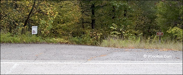
Look close to find the entrance for road 1119. It's between
these two small signs.
Directions - A very hard
road to spot. Watch your odometer, then look for a large drive apron dipping down quickly
into the woods. If you end up
at the Point 16 creekside pullout, you went too far.
Road Names - FSR 1119, Bear
Road.
New To Driving Back Roads? -
Read Our Back
Roading Tips
Where Does It Go? - There
are several ATV use roads along 1119. In 3.6 miles is the intersection with road 1139 at
the Forest Roads
Loop. This is also part of Horse
Trail C.
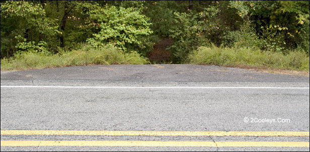
What Is It Like? - The road is paved for about 100 feet, then crosses a
small creek. After the creek, on the right, is a sandy parking area. It's just a circle
pullout. On some maps it shows as Flat Hollow. This is where to park for a tailgate
picnic, or a good place to catch a quick nap, or park your ATV trailer or horse
trailer. You can also walk this road for birding or relaxing. This is also access to
our back country road loops, and is also part of the Sylamore Walk-In Turkey Hunting area.
About 0.8 of a mile
up 1119 you'll come to two roads branching off FSR-1119. These will have gates. You can
walk down the roads, but if the gates are open we still recommend walking, not driving.
These are rough roads and they dead end. You'll find several other roads branching off
1119. Some of these roads are also horse trails, most are also ATV trails. All of them
make good walking trails.
ATV Use - FSR-1119
itself is approved for ATV use. So are many of the roads branching off 1119. Keep your
eyes open for the brown Carsonite signs at road junctions. These signs are not big, and
are about 5 inches wide and about 3 feet tall. They indicate which roads are for ATV use.
Sylamore
Walk-in Turkey Hunting Area. It's not just for turkey hunting! At the
intersection of 1119 and FSR 1102 you'll see signs for the Sylamore Walk-in Turkey Hunting
Area. This is a 9,300 acre part of the forest where all interior roads are closed to
motorized vehicles from March 15 through June 30 of each year. The roads shown on the
2Cooleys back country tours are not roads which are part of the interior protected area.
Any road that is closed will be marked. While dates change a little each year, turkey
hunting season is typically the last three weeks of April. The area is closed to vehicle
traffic during April and May because turkey hens and their broods get nervous at the sound
of engines. The closed roads make excellent places to hike and bird.
At 3.6 miles up 1119 you come to an
intersection with Sandy Flat Road, aka FSR-1139. If you turn to the left you will be on
Sandy Flat road. If you turn to the right you are still on 1119. Sandy Flat road
intersects with Green Road (aka FSR-1113 and CR-96) in about 3.5 miles. (Find Green Rd
info at Point 18).
Sandy Flat is the eastern border of the Experimental Forest Area.
At 6.5 miles up 1119 you come to
FSR-1140 aka Branscum road. Road 1140 is part of both Horse Trail A and B. This
trail runs north-south and cuts right through the center of the Experimental Area. It is not open to vehicle traffic, and
if it was you very definitely need 4-wheel drive. However, the gate at the south end is
closed.
At 7.5 miles is the intersection of
FSR-1119 and FSR-1102. This is the end of FSR-1119. Turning right or left puts you on
FSR-1102 (aka Gunner Pool or CR-102). Turn right and you'll come out on Hwy 5 at Point 12 in a
couple of miles. Turn left and in 0.3 miles you come to a "T" intersection where
FSR-1102 meets FSR-1101. Turn to the right onto 1101, which is also CR 75, to run another
loop toward either Point
35 or Point
11, or turn left to continue down FSR-1102 to head for Gunner Pool Rec. Area
and Point 25.
For details see Forest Roads
Loop.
If you do down FSR-1101 the first 3
miles are rough riding. This is one of the most remote areas on our tour. If you stay on
the roads you can't get lost as no matter which way you turn you'll come out on the main
road. (This is a beautiful area to really get way from it all.) The road surface is flat
and free of ruts, but the road is not graded frequently so its annoying but not harmful.
At about 3.3 miles you come to Baxter CR 132 and a couple of mail boxes. Shortly after
this point the road has no more homes or power lines, and the road becomes smoother and
wider. At 6.7 miles you come to the intersection of CR 75 and CR 74 (aka 1103). From here
you can run to either Point 11, Point 35, or Point 36. Turn
right to head toward Culp and Point 11 at Hwy 5. Bear left and you are heading toward
Point 35 at Hwy 341, which is 5 miles.
On some maps you'll see Tar Water Spring. Look for the little
drive apron to find the old road.
East Livingston Creek & Horse
Trail C - About 50 yards down Hwy 5 from the entrance to FSR 1119, and across Hwy
5, is a hidden entrance to an old logging road next to a pretty Ozark creek. This is Horse
Trail C, which follows an old road known as FSR-1147. This is a fun area to explore on
foot or ATV.
Back to Top
|