City
Rock Bluff
Point 11 Details
View Point At City Rock Bluff Special
Interest Area
On USDA Forest Property, Part of the Sylamore Ozark National Forest
Access To Extensive Back Roading Runs
2.1 miles between 10 & 11 
You Are Now In Stone County
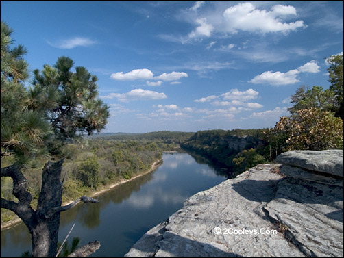
White River from top of City Rock Bluff, looking toward Calico
Rock
City Rock Bluff is a
walk-up view point putting you some 200 feet over the White River. This view point,
located in the Sylamore Ozark National Forest, gives a good look at the surrounding
Ozarks. This same point is a good place to follow Back Country roads.
Turn to City Rock Bluff Scenic Area
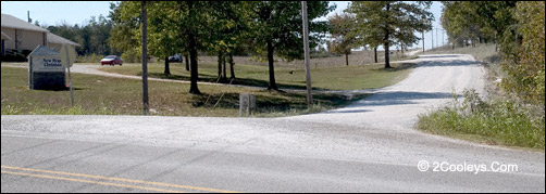
Directions - Point 11 on our map is at Culp
Road (aka Stone CR 53 and FSR 1105) at the New Hope Christian Fellowship church. After crossing the bridge over the White River at Calico drive a
little over 2 miles. Turn right
onto Culp Road and go 2.4 miles. This gravel road has some scenic views as well as
farmlands and cedar rock glades.
The short drive to City Rock Bluff Special Interest Area is
scenic
Road Surface - Culp Road can
be very dusty! Motorcycles can make it if you are careful in the loose gravel spots. There
will be mud puddles after a rain, and be quite dusty during dry spells. If you see dust
covering roadside trees and plants, then you know it will be a very dusty drive. However,
the dust is light and most of it will blow off at highway speeds. The mud is also easy to
wash off. The only thing you need to worry about is paint chips and dings in chrome. If
you take it slow, as in no more than 15 mph, you should be okay.

Parking at City Rock Bluff. Walk past the rocks and old sign.
Parking - When you reach
City Rock Bluff (Forest
Service property) you'll find a small parking
lot on the right surrounded by large boulders, and punctuated by a rusty metal sign frame. The Bluff is on the parking lot side of the
road. DO NOT LET YOUR CHILDREN RUN
AHEAD! IT IS OVER 200 FEET STRAIGHT DOWN IF THEY FALL! THERE ARE NO SAFETY RAILINGS!
The Views - Walk toward
the rusty old sign, go past it about 200 feet, and you'll find yourself on the edge of a
200 foot high rock wall. Look upstream (your left) for an old road. Where it meets the
river is the old Chesmond Ferry. Imagine crossing the river on a flat barge for a trip to
town. Look to your right (downstream) and you will see where you just came from - the City
of Calico Rock 2.5 miles away as a crow flies. City Rock Bluff shows up on many maps as
the City Rock Special Interest Area. It is Federal Property as part of the Ozark National
Forest. While the rock formations are part of the reason, there are also some very
interesting plants here. If you are a photographer you will find several macro subjects,
as well as landscapes.

In glades you'll discover wildflowers, birds, butterflies. It's
easy walking too!
Rock Glade - Across Culp
Road from the City Rock parking spot is a large rock glade. This area makes an excellent
wildflower walk, and is also fantastic for photographers who enjoy macro work. The glade
is on U.S. Forest Service property in the City Rock Bluff Special Interest Area.
Return To
Main Tour - When finished at City Rock Bluff you can drive back out to the main
tour loop to Hwy 5 to our point 11 and continue the main tour loop. Or you can head off
into the Back Country from here.
Main Tour Road Notes
For Hwy 5 After Point 11
Wildlife
Management Areas - Along this stretch of the Highway you'll see two Forest
Service signs. One announces you are entering the Sylamore Wildlife Management area, or
"WMA" for short. WMAs are areas set aside under different hunting and use
regulations. If you plan to hunt in this area make sure to pick up the regulations book
where you buy your license. Camping in WMAs requires a permit, which are available at the
Game & Fish office in Calico Rock.
Scenic Byway - The
second sign you'll see announces you are driving the Sylamore Scenic Byway, which simply
means you are driving through a National Forest.

Sugarloaf Hill, and the old fire
tower atop it, are visible for miles
Historical Note - Sugar
Loaf Mtn. Fire Tower - Before the days of satellite forest fire watch services,
fire towers were manned by rangers who used binoculars on the watch for smoke. From the
early 1900s through the 1980s fire towers all across the Ozarks were in use. None are in
use today. 3/4 mile from Culp Road (Point 11) you'll see a high hill with a fire tower on
top. This is Sugar Loaf Mountain Lookout. The road up to the tower (FSR 1123) is about 1.3
miles long and cork screws it's way up to 1,050 feet in elevation. The road is closed to
vehicles of any kind, but you can walk to the top. Drive in past the Road Closed sign. In
one-tenth of a mile you'll go past a couple of cabins. Just a few feet past the cabins
there is a pipe gate across the road. Parking space is limited to 3 vehicles. The road is
open to hikers and horseback riding. This is a good place to take a short walk for
birding. Trees block most of the view so unless you want a hard hike it really is not
worth the hike all the way up. Don't attempt to climb the tower! It is in bad shape.

The road to Sugarloaf fire tower is open to foot traffic. Drive past
this sign and park at the gate.
Sugar Loaf Creek -
Just past the tower road you'll cross a pretty creek named Sugar Loaf Creek. In this same
area you'll see a sign identifying this section of Hwy 5 as The Sylamore Scenic Byway.
Back to Top
|