Ozark Highlands Trail Crossing
Matney Camp Trail to White River
Point 40 Details
4 mi. between 39 & 40 
Foot hiking only, no ATV or Horse use
Hiking, Birding, Wildflower Walks
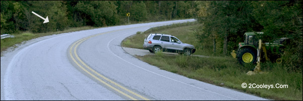
Be careful pulling in and out of this spot! OHT is where the
white arrow points.
Directions - This is not an actual trailhead
so there are no trailhead signs, the OHT simply crosses the road here. About 4.2 miles
from the Burnt Schoolhouse sign start looking for a sharp uphill curve to the right. Look
for where the guard rails change from one side of the road to the other. There is also a
yellow triangle caution sign saying 30mph with a 90-degree right-pointing arrow. You'll
also see yellow caution arrow signs pointing right. In the apex of this turn just before
the road starts uphill there is one of those small drive aprons on your right. Be
careful pulling in and out. Parking for maximum of three cars.
Where Does It Go? - If you
hike the Twin Creeks trail section south from Point 37,
this is where you'll come out. A nice short walk, or hike
to Ozark
Highlands Trail trailheads at either Point 37 or Point
42. Some maps may show this as the Matney Camp Trail. You'll see the OHT brown Carsonite signs marking the
trail on both sides of the road.
Hiking North - A Short 2 Mile Hike -
Cross the road and walk uphill about 100 feet and you'll see where the trail enters the
woods near a yellow triangle caution arrow sign. Continue to follow the OHT
trail another 2 miles to the last trail head on this section of the OHT. You'll come out
at Matney Knob Trail Head parking lot. This 2 miles is pretty easy, and is quite scenic as
you'll look down on the White River. The OHT trail follows Push Mountain Road (
State Hwy 341) along the pavement for a few hundred yards, then heads around behind Matney
Knob, which is the hill above you with the cell and radio tower.
Hiking South - The trail
enters the woods at the end of the short pull-in. It takes you south to Point 37
in about 7.4 miles. You can hike in a short distance for wildflower walks and birding.
The Matney Camp Trail -
From the parking spot cross Hwy 341 and walk in the opposite direction from the OHT. Go
about 100 yards and look close along the tree line. You'll see a trail sign for Matney
Camp, which is less than one-half a mile down the hillside. It ends up along the White
River. The hike down is easy. It's the hike back up the hill that gets you!
Back to Top
|