OHT
Brush Creek Trailhead
Point 33 Details
3.5 mi. between 32 & 33
The OHT is not authorized for ATV
or horse use - foot traffic only. At this time Brush Creek Road is not ATV authorized.

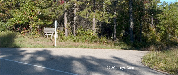
Brush Creek trailhead of the OHT is just past this sign
Directions - You'll see
the brown and white sign announcing the Ozark
Highlands Trail
Brush Creek Trailhead. Parking is right off the highway
on your right. Trail goes in both directions. Take short walks or hike to other
trailheads. Good parking, and a good place to start/end day hikes.
Take the trail on the parking lot side ( south)and you end up
at the trailhead on Cripple Turkey Road (Point 31) in 3.5 miles. Moccasin Springs OHT trailhead is 9 miles further
from the Cripple Turkey trailhead.
Cross Hwy 341 and hiking north takes you to Point 37
at Twin Creeks parking lot in about 3 miles. It is an easy 3 miles, but the last two miles get steep in places. It is
easier to hike from Brush Creek down to Twin Creeks Point
37, not the other
way.
Brush Creek Road is across the road from Brush Creek Trailhead
About Brush Creek Road - At Point 33 you'll
also find Brush Creek Road, aka FSR 1116. It's back down Hwy 341 about 100 feet and across
the highway from the trailhead. This is the northern boundary of the Leatherwood
Wilderness Area. At this time Brush Creek is NOT approved for ATV use. While you can drive
it in a car, the road is narrow and somewhat rough. It runs 9.5 miles and dead ends at
Cleveland Knob. About 8 miles
in, the road takes a sharp turn to the right. In this turn, off to the left, is what used
to be a parking lot for a trail. You'll see the old sign marquee there. This trail is no
longer used or maintained and has grown in. Narrow and rougher after this point, Brush
Creek Road dead ends up on Cleveland Knob about 1.5 miles from the old trail sign. There
is nothing on the knob, but you can get good cell signal there. Years ago Cleveland Knob
was another fire tower site.
Back To Top
|