Turn
Onto Push Mountain Road
Point 28 Details
2.2 miles between 27 &
28
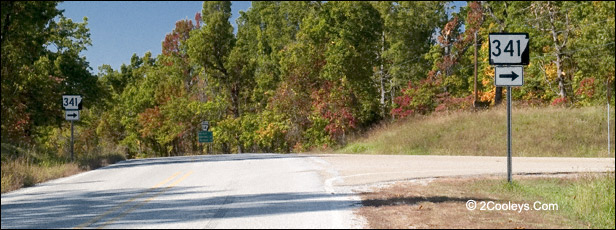
Junction of Hwy 14 and Hwy 341 - aka Push Mountain Road
This is the remote section of our tour.
It's scenic any time of year, but is especially beautiful during spring and fall foliage.
For gas and food in this area click here.
Road
Names - Highway 341, Push Mountain Road, FSR-1100
Good Pull-Out Here - If
you need a place to pull over to read this map or whatever, go about 50 feet past the
intersection and there's a good-sized parking spot there.
Main Tour Loop Turning Point
- Don't Miss This Turn! - As
you approach this intersection you'll see a green and white highway sign showing arrows
for Mountain Home and Yellville. Just past this sign before the turn you'll see the
highway sign for Hwy 341, aka Push Mountain Road and FSR 1100
What's Here - Push
Mountain Road is a typical Ozark Mountain road. It winds, climbs, and drops like a long
roller coaster ride. Smooth, paved two lane road. Winding and scenic. A favorite with
sports car and motorcycle enthusiasts. All along this highway are numerous Back Country
Runs, access roads to both the Ozark Highlands Trail (OHT) trailheads, and the North
Sylamore Creek Hiking Trail (NCST) trailheads. Anywhere along this highway are several
spots to pull onto back roads for birding, wildflower photography, and exploring.
Push Mountain Road Hazard
Warning! Because of it's sharp
curves it is important that you always stay in your lane on this road. Your life, as well
as lives of others, could depend on it.
For your safety and that of others,
PLEASE STAY IN YOUR LANE AT ALL TIMES.
ATV & Horse Use Areas
- Between Points 28 and 37 are
approximately 17 roads and old logging trails were ATV use is legal. (Just after you pull
onto 341 you'll see FSR 1121 and FSR 910338 where ATV use is allowed.) Along these roads
are road branches where ATV use is also legal. To determine where you can, and cannot, run
an ATV, always look for the brown Carsonite (fiberglass) posts sticking out of the ground.
These brown sign posts are about 4 inches wide and 3 feet tall, They have six digit road
numbers which always start with 910. . . Under the number will be an ATV symbol, and a
horse symbol. If the ATV symbol does not have a red slash through it, you can operate an
ATV on this road. Same for horseback riding. For details please see our ATV Use Guide
, and our Horse
Trail Guide.
Little
Short Driveways - All along Hwy 341 you will see what looks like very short
driveway aprons. They make a great place to park for a birding or a wildflower walk. Some
50 years ago all of these drive entrances did indeed serve as an entrance to a farm lane
or road. That was back in the days when the area was not a National Forest. When the road
was paved back in the 1930's by the State, the State was legally obligated to hard surface
all roads and drives to the edge of the State Highway easement. These little drive
entrances make an excellent place to park if you want to stop. However, be extremely
careful not to park in a curve. Pulling back out of these spots can be very dangerous near
curves as traffic coming around a curve will not have time to stop!
Old Logging Roads -
All along Hwy 341 you will see old logging roads, many of which are still in use by
logging operations, hunters, hikers, and anyone else who enjoys getting out in Nature.
These old roads make a great place to go for a walk. The old roads are much easier to walk
than hiking trails.
Back County Roads -
All of the roads on our map that are laid out in green are Back County roads. We recommend
reading our Back
Country Runs Guide before going down these roads very far. All of them are
well maintained dirt roads, but you can rarely go more than 15 mph on them. Many are
dead-end roads. If you venture down any of these roads without first reading our Guide,
keep a couple things in mind. First, always be on the lookout for a good place to turn
around. Second, remember that most cell phones will not work in these areas. Third, if you
do have problems of any kind, the farther in you go, the further you will have to walk
back out to the highway. The chances are slim anyone will drive past you on some of these
roads.
Working Forest -
The Sylamore District is a National Forest, not a National Park. A National Forest issues
permits to logging operations. You may see timber cutting in process, and you may see
logging trucks on this road.
Ice Damage - Along
Hwy 341 you will see torn-up trees, looking like they were in a battlefield. This damage
was caused by a heavy ice storm in February of 2009 which dropped 2 inches of ice on
everything. Most trees on these ridges lost the top 15 to 20 feet of their height, as well
as most of their larger limbs. This damage will be more apparent when the leaves are off
the trees. They'll look like tall telephone poles with little short branches.
Gas
& Food
Gas,
Store, Food, Liquor - If you need gas or convenience store items, if you want a
meal, or if you want to purchase liquor, you can do so 5 miles down the road on the other
side of Big Flat. At the junction of Hwy 263 & Hwy 14 is Susie Q's Kountry Kitchen,
Charley's Place, & Junction Liquor. All three are close together at the triangle
junction of Hwy 263 and Hwy 14 just past Big Flat.
Susie Q's - 870-448-2088
8505 Highway 14 & 263, Big Flat, Arkansas. Convenience store, gas
station, and restaurant. Bright red metal roofs, beige metal siding. Burgers, chicken,
salads, pizza, etc. A great place to stop for a break, we've come here for years and
always enjoy it. Picnic tables outside offer a pretty view. Excellent homemade pies! Open
Monday through Thursday 6am to 8pm, open Friday and Saturdays from 6am to 9pm, open
Sundays from 11:30am to 3pm.
Junction Liquor - 870- 448-5139 Where
Hwy 14 and Hwy 263 meet. Open 8am to 10pm six days a week, closed Sundays.
Charley's Place is
a small bar at the same intersection.
Big Flat (pop. 104) zip code: 72617
Back to Top
|