North
Sylamore Creek Hiking Trail
Point 22 Details
Allison Trail Head for the NSCT Hiking
.5 mi. from Anglers
Resort 
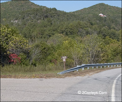
Look for this tiny little sign next to the guard rail
This is the downstream end of the North
Sylamore Creek Trail (NSCT). A little over 23 miles long, the NSCT runs through the center
of the North Sylamore Creek National Scenic River Corridor.
Day Hike - This is the start of the
23.75 mile North Sylamore Creek Hiking Trail. Hike 4.7 miles up to the next
trailhead at Blanchard Springs, or keep going. If you hike this section you will have to
cross Sylamore Creek, which can be tricky if the water is high. This is the only section
of the trail you need to cross water. Determine the water level down at Anglers where the
Sylamore flows into the White River. If it looks high we recommend not hiking this
section.
Directions
- Coming up from Anglers on Hwy 14, as you cross the bridge going over the South Sylamore
Creek you'll see guardrails. The road changes to a three-lane highway on the uphill side
of the bridge. At the end of the guardrails look for the brown and white sign that says
"Hiking Trail". Turn right and go down a steep narrow road that heads downhill
3/4 mi. into the river bottom. At the end of the road you'll see a long silver guardrail.
In the center of the guard rail is an opening, this is the trailhead. This trail is for
human foot traffic only. No horses, no bicycles, no ATV's.
For a complete description of the
NSCT visit:
http://www.ozarksociety.net/new_sylamore_trail_information.htm#NORTH_SYLAMORE_
Continuing On The
Main Tour Loop
North Sylamore
Creek National Scenic River Corridor
Points 19 through 27
Highway 14 is also
part the Sylamore Scenic Byway
6.4 miles from Anglers to
Hwy 87
6.8 miles to
Blanchard Springs from Anglers
7.9 miles to
Fifty-Six from Anglers
8.9 miles from Anglers is
the turn to Gunner Pool Rec. Area
Back
to Top
|